 |
It seemed to be an innocuous proposal – setting up of an alternative weekly market at the outskirts of Shillong, after the city’s bustling traditional market, Iewduh, was shut down in response to the raging COVID-19 pandemic. And why not! Many might have thought; after all, it would be a win-win situation for both the rural farmers, who had been desperately looking for new avenues to sell their produce, and for the panic-stricken urban consumers ever ready to lap up any amount of fresh fruits and vegetables that came their way!
Instead, the proposal met with stiff resistance!
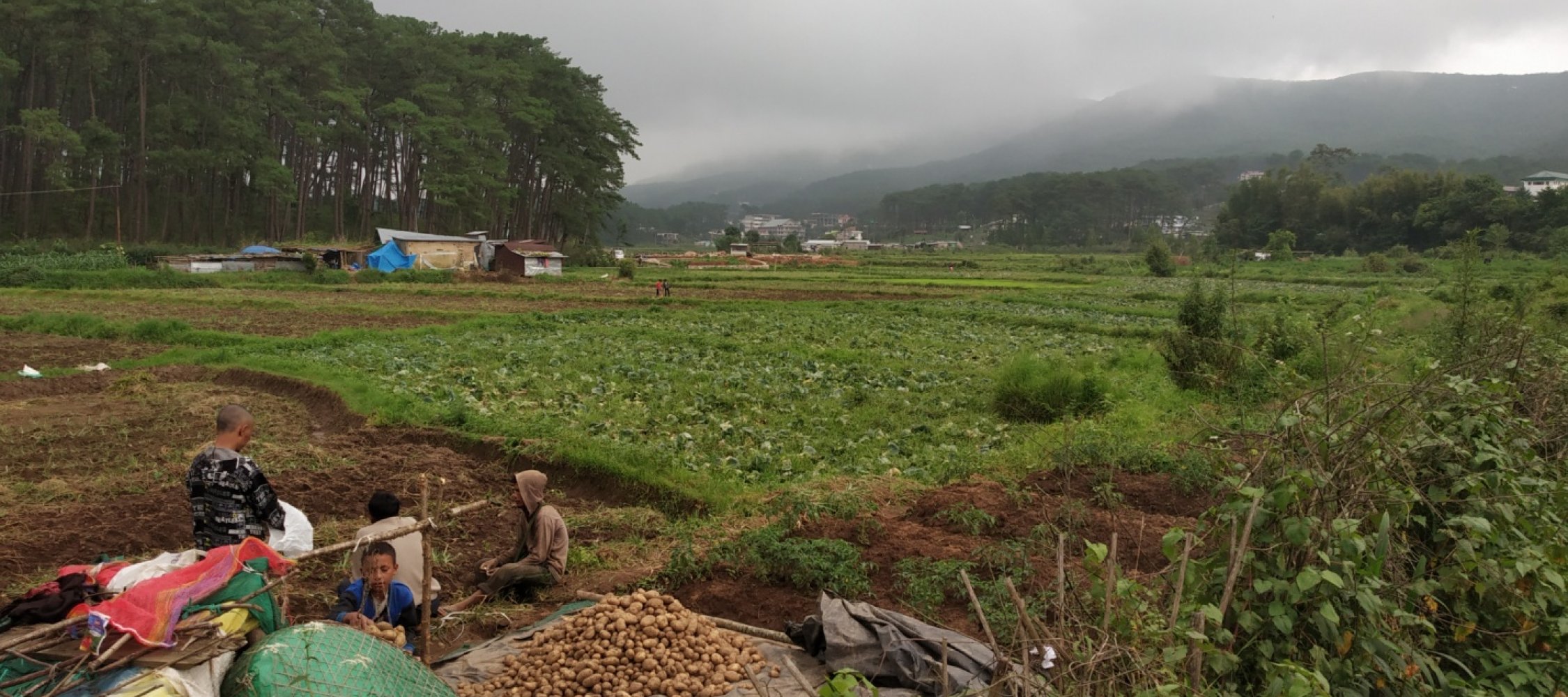
“We are not going to allow any market, no matter how urgent and useful it may be at Mawlai-Mawroh area,” said S.D. Khongwir, president of the influential Mawlai Town Dorbar. He said this forest, which is a part of U Lum Syiem Lum Mawpat ridge and the prime catchment, is dotted with natural springs and streams. The proposed site for the weekly market is said to have been chosen bang in the middle of the dense pine forest.
The local leaders of the Mawlai Town Dorbar that comprises at least 16 localities with a population of over 50,000 demanded that the proposal, which they say was ill-conceived, must be withdrawn forthwith.
The communities settled down around the burgeoning Mawlai-Umshing-Mawkynroh-Mawtawar areas in the lap of U Lum Syiem Lum Mawpat have set aside this pristine pine-forested hill as ‘community reserve’ under the aegis of the Hima Mylliem administration and the dorbar (council) to secure their present and future water needs.
Khongwir, a former deputy chief minister who is serving the dorbar as its chief functionary since 1968, argues that the proposed market, mooted jointly by the Khasi Hills Autonomous District Council (KHADC) and the Syiem administration of the Hima Mylliem (chief of traditional state administration of Mylliem), would lead to clearing of hundreds of standing trees and destruction of all the natural water sources of the area.
“This will cause drying up of the existing natural springs and drastically reduce the volume of water that feeds the decades-old Mawlai water supply networks,” he told this writer. Therefore, “the entire catchment area of U Lum Syiem Lum Mawpat has to be protected at any cost,” he asserted.
Nine ‘eternal springs’
“This is not a mere Khasi mythology. In fact, all the nine rivers can be traced and identified,” he said.
According to him, of the nine five streams besides other small tributaries – Umshyllong, Umjasai, Umshyrpi, Umkhrah (all the four streams eventually join together to form the river Umiam-Khwan) and Umkhen – flow north towards the Brahmaputra valley in Assam. The other four rivers Umngot, Umiew, and two other streams – Umtongsyiem or Umtangsyiem and Umjlieng (both join Wah Umiew) – roll down the southern slopes, cutting through deep ravines and narrow valleys and out fall into the Surma river in Bangladesh.
The entire Shillong range that includes U Lum Syiem Lum Mawpat serves as the critical catchment area for all the major rivers flowing down from its northern and southern slopes. Along their way, numerous rivulets and streams pump in more water and force, as they pass by thousands of Khasi villages settled across the river basin. The rivers also carry nutrients to enrich the low-lying lands. For generations, indigenous farmers have been toiling on those lands, turning them into profitable ‘rice bowls’ and ‘vegetable baskets’ and sustaining their lives and livelihoods.
Most importantly, the ever growing population in Shillong, the picturesque hill capital of Meghalaya, and other expanding urban localities around the city, entirely depend on the waters of the ridge forests – especially of the river Umiew, which feeds the Greater Shillong Water Supply networks to ensure availability of running water to the urban households of the city.
Years back, recognising its immense importance, the government had declared as a protected ‘green belt’ the entire Shillong ridge, which is critical to the survival of the present and the ensuing generations.
Manik Syiem says the Hima Mylliem is one of the principal custodians of U Lum Syiem Lum Mawpat, and it is the bounded duty of the incumbent leadership to make sure that the prime forest is protected and conserved, and not allowed to be exploited by vested interest. Two decades ago, as the chief of Mylliem administration, he had spearheaded a transformative initiative – ‘change with time’ - with a view to enabling and empowering the traditional institutions of self-governance to strengthen and improve their functioning and efficiency.
Of course, this is not the first time that attempts were made to clear the forest and convert it into private properties. Several years ago, maybe the year 2009-10, recalls Khongwir, the then Syiem of Hima Mylliem tried to dispose of a large part of the forest lands at Mawroh. Many plots were distributed among some of his myntries (ministers) and officials of the Hima to buy their loyalty. Some of the beneficiaries even demarcated their plots by erecting stones and pillars. But this plan was soon foiled by the people of Mawlai, who one day turned up in hundreds at the spot and pulled down all the stones and pillars to give vent to their anger and disappointment with this unscrupulous action of the then Syiem.
There is another issue, which has been raised by Dr. Sandy Syiem, the director and top physician of San-ker, a well-known drug de-addiction cum mental health and healing centre of the state, located in the salubrious clime at the foothills of the Mawpat ridge. The proposed market site is said to have been identified just beside the entrance of the hospice.
“First of all”, Dr Sandy Syiem pointed out, “a nice patch of pine forest that stands tall in front of the hospital, and acts as a natural air and water purifier, has to be felled to make way for the market buildings. This is totally undesirable and unacceptable”.
Moreover, apart from the hustle and bustle of the marketplace, its activities are likely to generate a lot of unwanted garbage, including littering of plastic items/ materials, and pollute the natural spring, which is the only source of water for the hospital, thereby vitiating the surrounding environment. “How can this be allowed,” the visibly perturbed doctor asked.
“It’s not the Mawlai-Umshing-Mawkynroh region alone that is solely dependent on the waters of the Mawpat forest,” Manik Syiem said. He took this writer on a quick tour along the course of the Wah Umshing downstream to explain how the rural communities settled across the Umiam-Khwan river basin make use of the flowing water – fishing, irrigating paddy fields, growing vegetables and various horticultural produce. “It’s important to understand this upstream-downstream connection, while addressing the water-related issues,” he added.
It is obvious that the river Umshing can’t survive unless the catchment areas of U Lum Syiem Lum Mawpat range are protected from selfish human actions.
The river Umiam-Khwan, is born out of the union of two popular streams - Wah Umkhrah and Umshyrpi, both originating from the legendary Shillong range. The two streams together happily meander downhill through numerous gorges, creating stunning waterfalls of Bidon and Bishop near Sonapani (golden water). Unfortunately, its bubbling natural flow is stalled in its mid-course by a concrete dam at Umiam, pounding all waters into a reservoir (generally known as, the ‘Barapani lake’, a major tourist attraction) to run one of the state’s oldest hydro-power projects.
However, even as the flow of Umiam was reduced to a trickle due to the dam, it found a new lease of life with the support of “her youthful little sister”, the river Umshing, which closely followed “her elder sister” and met just a few hundred metres below the dam at the original confluence of the “two river sisters”. From there the rejuvenated ‘sisters’ joined by several other streams traverse across the basin till it reaches the Assam plains.
It’s a common knowledge that a well protected forest offers a number of natural goods and services – fresh air, clean potable water, food, fuel, healthcare, healing and recreation. And here comes the urgency of collective community action for safeguarding the commons or the common property resources and other natural endowments inherited from their ancestors.
Communities are fully aware of the need for permanent protection of the entire stretch of the Shillong-Laitkor range, including U Lum Syiem Lum Mawpat and yet it is exposed to all kinds of anthropogenic pressures – illegal logging, quarrying and sand mining. But then, it is not gainsaying that with rising population, rapid urbanisation, and resultant expansion of basic amenities and infrastructure – roads, housing, safe potable water and electricity – pressures on environment and natural resources will continue to mount.
Shillong city is facing an existential crisis. From a small settlement of less than 1,500 inhabitants in 1874, when the British set up its first hill station in Shillong, it has grown into a crowded cosmopolitan state capital of Meghalaya, with a multi-ethnic population of over 3.5 lakhs (2011 Census). According to a city master plan (1991-2011), the population is projected to shoot up to over seven lakhs.
Despite having an average annual rainfall of over 3,500 mm, it is facing acute shortage of water, especially during the dry winter months. The urban planners are wary of severe stress on the existing urban infrastructure being exerted by the swelling population as people from rural areas and economic migrants from outside the state continue to pour into the city. The situation is likely to cause local anxieties and resultant frictions between localities over water-related issues.
A few years back, when the Mawroh-Umshing-Mawkynroh alternative road was built across the foothills of the Lum Syiem, people grudgingly allowed that project to ease the growing vehicular traffic in the highly congested Mawlai localities. But once the road came up through the forest, people began to settle down thick and fast, clearing up more and more catchment forest land and turning it into a concrete jungle.
Politicians and bureaucrats often cite the existing land tenure system (that is, land and its resources belong to people) for the government’s failure, and even inaction in mitigating many of these challenges. Critics, however, rubbish such weak explanations and blame them for their non-performance, poor governance, lack of efficiency, and accountability.
It’s true, the customary rights and ownership of land and its resources by indigenous communities are guaranteed under the Sixth Schedule of the Indian Constitution. The traditional institutions of the respective indigenous communities are responsible for land and resource management. Given this context, neither the state government nor the district council has been able to sufficiently engage with the traditional grassroots institutions, which still hold immense influence on the community in matters related to natural resources use and their governance. The importance of their role has been generally ignored by the state government.
This attitude has to change. The state government and its agencies have to work with the community institutions and their leaders while implementing land and natural resource-based projects. Take, for example, the ongoing World Bank funded Meghalaya Community-led Landscapes Management Project (MCLLPM).. The principal objective of the project, launched in 2018, is to support landscape restoration activities with the help of local communities. About 400 villages located around a few highly degraded landscapes have been identified to implement the project.
It proposes to develop an integrated landscape development plan to be implemented by the community under the guidance of the state government. Provisions have also been made in the plan for training and capacity building of the community institutions and leaders so that they can actively participate in the decision-making process and its execution.
The project offers a big opportunity for deeper involvement and better collaboration between the government and the local communities to find solutions to complex problems. The challenge is how to find a balance between economic development for human prosperity on the one hand, and securing social and environmental justice for all, on the other.
This case study represents one of such challenges.
Postscript : As this story goes for printing, Mawlai Dorbar happily informs that the weekly market project at Mawroh has been scrapped.
Geolocation is 25.598186311053045, 91.92266767699257


