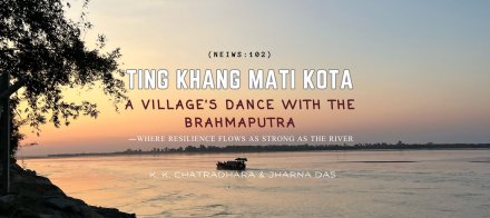
 |
Almost every year in the monsoon months, Kobo Chapori, a tiny island in the bosom of the river Brahmaputra in upper Assam, pops up in the disaster radar, calling out for emergency support as the swirling floodwaters lash it out! For days the isolated island community would bear the relentless onslaught of flood and the uncertainty of their lives and livelihood. Once flood water recedes, Kobo Chapori would go into oblivion, leaving the distraught villagers to fend for themselves until another disaster strikes it again!
“That’s been our story at Kobo Chapori,” lamented Kuldeep Tamang, the gaon bura (headman) of No2 Kobo Chapori village. He said the island communities were victims of both natural calamities and official apathy towards their problems.
Kobo Chapori (or Kobu Chapori) finds itself exposed to the fury of recurring floods and riverbank erosion. But it is no ordinary river island; it represents a unique ecological space. A critical wildlife corridor connects the Poba reserve forest with the Daying Ering Wildlife Sanctuary on the north in Arunachal Pradesh and the Dibru-Saikhowa National Park in Assam on the south. Also, it is just about a few kilometres downstream of the confluence (at the longitudes 95°13.82 east and the latitudes 27°43´ north) of Dehang (Siang), Dibang, and Lohit rivers to form the mighty Brahmaputra.
Kobo Chapori, now reduced to about 7,300 hectares, comprises four villages – No. 1 Kobo Chapori, No.2 Kobo Chapori, No.3 Kobo Chapori, and No. 4 Kobo Chapori – with a total of 654 families (3,840 people). It falls under the Sille panchayat of Jonai revenue circle in the Dhemaji district. One has to take a one-hour boat ride from Jonai to reach the river island.
“My father often used to say till his last breath, ‘we have been blessed with undisturbed calm and the serene Brahmaputra till the Great Earthquake of 1950 razed everything to the ground’,” he said.
“All this had been the thrust points of changing phenomenon of floods and erosions in the whole of the upper Brahmaputra river basin, including Kobo Chapori,” averred Tukheswar Miri Agarwala, a teacher and an environmental activist, who has been working for the protection of the Poba reserve forest since the 1990s.
Moreover, Tamang admitted: “The knowledge and skills that our forefathers transferred to us and what we learned through interaction within ourselves (that is, the exchange of knowledge and skills among the different island communities at that point of time) were not adequate for us to adapt and survive in the post-earthquake period.” These uncertain conditions resulted in substantial outward migration from Kobo Chapori, literally turning the place into a ‘jungle’. Of course, he said, few of the families, including his own family, willingly or unwillingly stayed back. “The waters of Brahmaputra were calm and serene, which welcomed us to Kobo then. Now, the same river has turned quite rough and furious, forcing us to leave the island during the post-earthquake period,” he sighed.
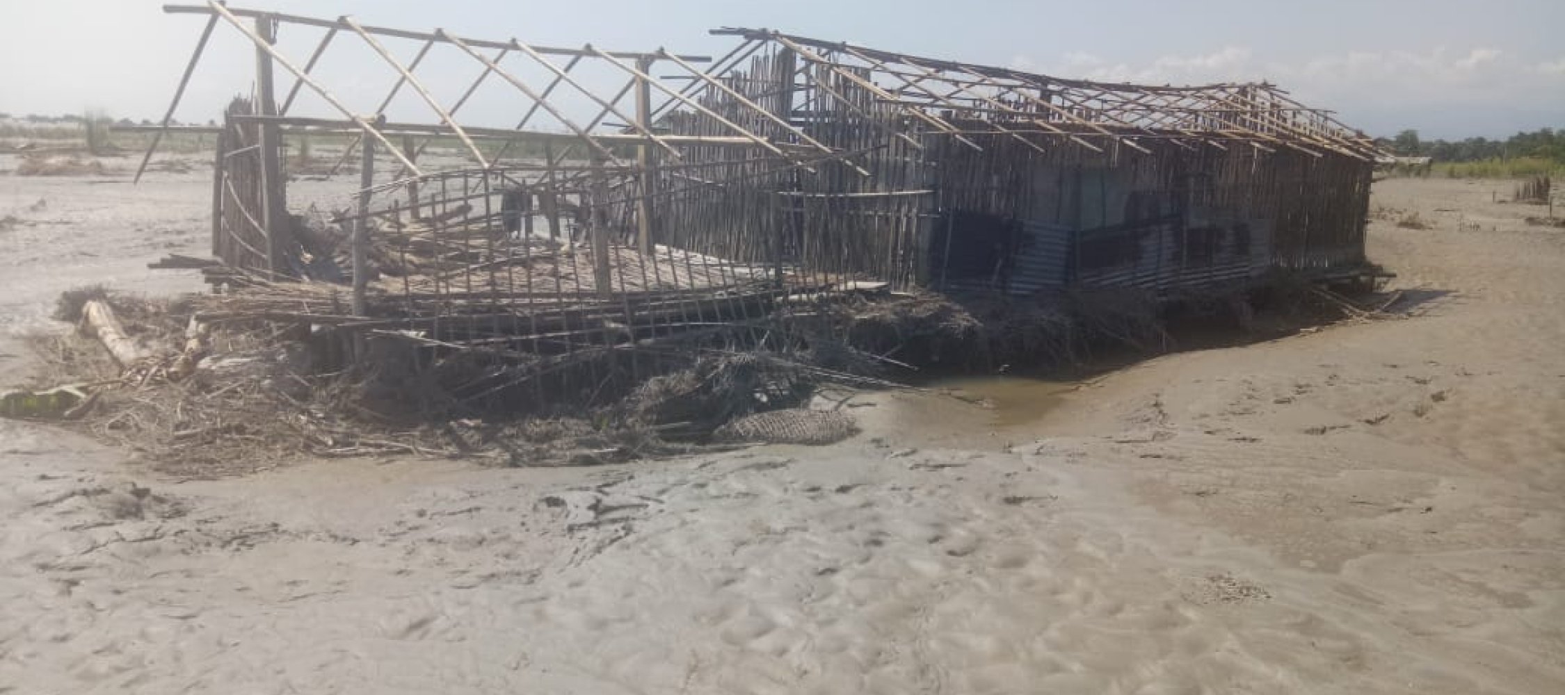
The situation turned worse in June 2000, when an unprecedented flash flood ripped through the Kobo Chapori. Twelve out of the total 16 villages were wiped out overnight, and hundreds of families lost their homes, croplands, and livestock. In risky emergency operations, about 168 families were rescued, airlifted, and later on resettled at Simen Chapori, another river island about 100 km away west of the Kobo areas.
The flash flood of 2000, it was widely believed, was a human-made phenomenon. Reportedly, a breach in an earthen dam on the Yarlung Tsangpo in the Tibetan Autonomous Region (under Chinese occupation) released a massive flow of water, causing a rapid surge downstream in Arunachal Pradesh and Assam. The deforested riverine terrain in the upper reaches of the river Siang in Arunachal Pradesh primarily failed to mollify the high flow, which caused a devastating flash flood in upper Assam, and the trails of which are still felt across the Kobo chapori in annual flooding and erosion.
The Great Earthquake, a natural calamity, created a new hydro-geo-ecological setting of the Brahmaputra basin. In the last 50 years, the riverine communities gradually learned to live with the change. But, the flash flood of 2000 was a result of human folly and adventurism. “It was due to our tampering with nature. The rampant destruction of catchment forest in the upper reaches, sand mining and boulder extraction from the river bed, and constriction of tributaries – all contributed to unpredictable river behaviour and associated hazards, and human misery,” Tamang opined.
We were shocked to see the ravaged island and its distressed inhabitants. Nearly 1,000 people took shelter in temporary makeshift camps (made of bamboo and jungle leaves). Most of them were women and children clad in one piece of cloth, lying on the floor strewn with thatch. People, searching for safe areas, were forced to leave their ancestral lands amidst the river Brahmaputra’s unabated erosion. There was no sign of standing crops or stored grains, and people were surviving on meager gratuitous relief provided by the government two days back. Ponds and the river were the only sources of potable water. Altogether 108 families (about 750 people) had been airlifted by the government to the designated relief camps in Jonai.
The immediate task was to provide food relief for one month for 313 families. We closely worked with the gaon bura and representatives of the circle officer of Jonai revenue circle. Under the aegis of the RVC, the community-based Duryug Pratirodh Samiti (DPS) was set up. The main objective was to train the DPS members and build their capacity to provide an effective emergency response at the community level and institutionalise a community based disaster preparedness (CBDP) and management plan.
In other words, the RVC worked on a two-pronged strategy – first, immediate relief for the flood-affected families, and then, help their rehabilitation in the post-flood period. A detailed plan that included
(i) setting up of several task forces (TF) on early warning, rescue, camp management, communication, water and sanitation, and first-aid;
(ii) construction of shelter and village roads through food-for-work (FFW) programme; and (iii) promotion of sustainable WASH practices and installation of community hand pumps and latrines was laid out to help boost the community resilience.
The DPS-led disaster preparedness approach worked well for a few initial years. However, the CBDP process soon began to weaken, mainly due to massive outward migration of the youth from the Kobo Chapori areas.
Recalling the earlier outmigration after the Great Earthquake, Tamang said, between 1950 and 1965, many families left the devastated Kobo Chapori in search of secure land and livelihood. Meanwhile, the island went through its natural renewal process, and several families also started to return. “Our people could not stay away for long from the amazing landscape of Kobo Chapori, its land, wetland, forests, the diverse climate all enriched by the river Brahmaputra,” Tamang said. Not that the Kobo Chapori regained its past glory, but people found it still attractive as they began to explore ways to rebuild their lives around water. “Fish, dairy, waterways were the new avenues apart from agriculture and livestock rearing, which our people took up in right earnest,” he added. People have been struggling but have somehow managed to stay afloat. Then all of a sudden, came the killer flood of 2000, which washed away everything.
According to official records, in the last 20 years, the island had lost about 355 hectares of land to erosion, and another 388 hectares of fertile land had turned barren because of sand deposition. “We now cannot go for cultivation of Rabi crops, because our lands have become either intensively sandy or marshy. The wetlands, which used to feed our winter crops and supply us with abundant fishes are now filled up with sand,” said Tamang. The crises for survival have reached such a height that migration to other states has reached its peak. In the last five years, he added, , 505 men and 80 women – all youth, including teenagers – from 300 households migrated to other states in search of jobs.
It is ironic that Kobo Chapori is surrounded by water, which is not quite potable. Why? Tamang’s wife said women had to walk several kilometres to find drinking water. “Even in the summer when we live amidst water, rarely do we have access to potable water,” she said.
Like potable water, sanitation is also a problem that we have been reeling under. The hand pumps and the latrines that the concerned departments – panchayati raj institutions, autonomous councils – try to promote in the area hardly sustain a single monsoon because of its non-flood resilient feature. People are forced to go out in the open for defecation, but it is quite difficult for women to walk a long distance to find safe and convenient places, she complained.
Since October 2019, discussions and meetings with PRI members, community elders, women self-help groups (SHGs) for preparation of gram panchayat level risk-informed maps, and disaster management plans have been initiated. A series of participatory exercises was also conducted in Kobo Chapori with gram panchayat leaders and the community. Two of the major concerns that have emerged from the exercises are: Risks associated with safe drinking water, sanitation, and menstrual hygiene.
The RVC has presented a slew of flood-resilient low-cost, safe water and sanitation structures, which have been promoted in other flood vulnerable areas of Dhemaji, Majuli and Lakhimpur areas since 2005. It has also offered its support whenever it is sought for by the community as well as the gram panchayat leaders of Kobo Chapori.
Geolocation is 27.831809448931097, 95.40483134429176
All rights reserved NEIWT 2023
(link is external) (link is external) (link is external) (link is external)
newatertalk@gmail.com